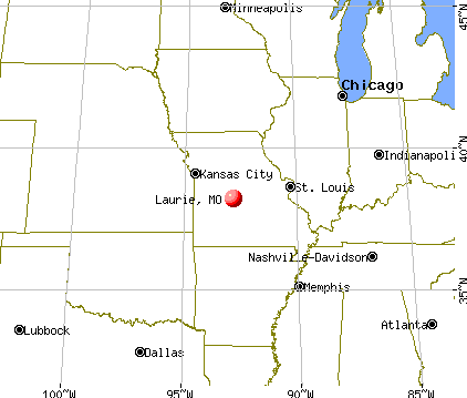
Laurie, Missouri

Submit your own pictures of this village and show them to the world
- OSM Map
- General Map
- Google Map
- MSN Map
Population change since 2000: +53.1%
| Males: 415 | |
| Females: 600 |
| Median resident age: | 62.2 years |
| Missouri median age: | 39.1 years |
Zip codes: 65037.
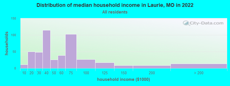
| Laurie: | $42,912 |
| MO: | $64,811 |
Estimated per capita income in 2022: $28,391 (it was $18,023 in 2000)
Laurie village income, earnings, and wages data
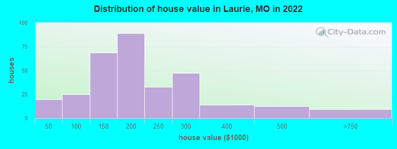
Estimated median house or condo value in 2022: $181,930 (it was $92,600 in 2000)
| Laurie: | $181,930 |
| MO: | $221,200 |
Mean prices in 2022: all housing units: $226,384; detached houses: $236,987; townhouses or other attached units: $118,090; mobile homes: $75,602
Median gross rent in 2022: $776.
(9.2% for White Non-Hispanic residents, 21.2% for two or more races residents)
Detailed information about poverty and poor residents in Laurie, MO


Compare current foreclosures near Laurie, MO:
| Photo | Address | Area | Beds / Baths | Price | Details |
|---|---|---|---|---|---|

|
#1
Old Fifty Four Rd # 54
Camdenton, MO 65020
|
- sq. feet
|
1 baths 2 beds |
$19,900
|
show details |

|
#2
Saint Tropez Cir
Osage Beach, MO 65065
|
1,253 sq. feet
|
4 baths 4 beds |
show details | |

|
#3
Buckingham Dr
Camdenton, MO 65020
|
2,963 sq. feet
|
4 baths 5 beds |
show details | |

|
#4
Bittersweet Rd # 1102
Lake Ozark, MO 65049
|
- sq. feet
|
3 baths 4 beds |
show details | |

|
#5
Overlook Rd
Lake Ozark, MO 65049
|
1,458 sq. feet
|
- baths 3 beds |
show details | |

|
#6
Glenwood Rd
Eldon, MO 65026
|
1,118 sq. feet
|
- baths 3 beds |
show details | |

|
#7
Witt Rd
Eldon, MO 65026
|
- sq. feet
|
- baths - beds |
show details | |

|
#8
Skywater Rd
Gravois Mills, MO 65037
|
- sq. feet
|
- baths - beds |
show details | |

|
#9
Matson Ln
Linn Creek, MO 65052
|
- sq. feet
|
- baths - beds |
show details | |

|
#10
Enid Ln
Camdenton, MO 65020
|
- sq. feet
|
- baths - beds |
show details |
| Photo | Address | Area | Beds / Baths | Price | Details |
|---|---|---|---|---|---|

|
#11
State Road Y
Linn Creek, MO 65052
|
- sq. feet
|
- baths - beds |
show details | |

|
#12
Mace Rd Apt 4
Osage Beach, MO 65065
|
- sq. feet
|
- baths - beds |
show details | |

|
#13
Highway Mm
Versailles, MO 65084
|
- sq. feet
|
- baths - beds |
show details | |

|
#14
Mace Rd
Osage Beach, MO 65065
|
- sq. feet
|
- baths - beds |
show details | |

|
#15
Oak View Rd
Osage Beach, MO 65065
|
- sq. feet
|
- baths - beds |
show details | |

|
#16
Witt Rd
Eldon, MO 65026
|
- sq. feet
|
- baths - beds |
show details | |

|
#17
Pecan St
Eldon, MO 65026
|
- sq. feet
|
- baths - beds |
show details | |

|
#18
Bent Tree Ln
Camdenton, MO 65020
|
- sq. feet
|
- baths - beds |
show details | |

|
#19
Fall St Unit A
Osage Beach, MO 65065
|
- sq. feet
|
- baths - beds |
show details | |

|
#20
Mailhack Rd
Macks Creek, MO 65786
|
- sq. feet
|
- baths - beds |
show details |
| Photo | Address | Area | Beds / Baths | Price | Details |
|---|---|---|---|---|---|

|
#21
Lain Ln
Macks Creek, MO 65786
|
- sq. feet
|
- baths - beds |
show details | |

|
#22
Country Club Shores Rd
Camdenton, MO 65020
|
- sq. feet
|
- baths - beds |
show details | |

|
#23
Marion St
Versailles, MO 65084
|
- sq. feet
|
- baths - beds |
show details | |

|
#24
Doc Ridgeway Rd
Roach, MO 65787
|
- sq. feet
|
- baths - beds |
show details | |

|
#25
Hays Dr
Eldon, MO 65026
|
- sq. feet
|
- baths - beds |
show details | |

|
#26
Tonka Spring Rd
Camdenton, MO 65020
|
- sq. feet
|
- baths - beds |
show details | |

|
#27
N Maple St
Versailles, MO 65084
|
- sq. feet
|
- baths - beds |
show details | |

|
#28
Mcdonald Ave
Versailles, MO 65084
|
- sq. feet
|
- baths - beds |
show details | |

|
#29
Velvet Dr
Camdenton, MO 65020
|
- sq. feet
|
- baths - beds |
show details | |

|
#30
Camden Manor Dr # 10
Camdenton, MO 65020
|
- sq. feet
|
- baths - beds |
show details |
| Photo | Address | Area | Beds / Baths | Price | Details |
|---|---|---|---|---|---|

|
#31
Osage Beach Pkwy Ste A
Osage Beach, MO 65065
|
- sq. feet
|
- baths - beds |
show details | |

|
#32
3 Seasons Rd
Osage Beach, MO 65065
|
- sq. feet
|
- baths - beds |
show details | |

|
#33
Baydy Peak Rd
Osage Beach, MO 65065
|
- sq. feet
|
- baths - beds |
show details | |

|
#34
Trevino Rd
Gravois Mills, MO 65037
|
- sq. feet
|
- baths - beds |
show details | |

|
#35
Cherokee Dr
Rocky Mount, MO 65072
|
- sq. feet
|
- baths - beds |
show details | |

|
#36
Wolf Pen Holw
Camdenton, MO 65020
|
- sq. feet
|
- baths - beds |
show details | |

|
#37
Cherokee Rd # 2a
Lake Ozark, MO 65049
|
- sq. feet
|
- baths - beds |
show details | |

|
#38
Crawford Dr
Sunrise Beach, MO 65079
|
- sq. feet
|
- baths - beds |
show details | |

|
#39
Village Marina Rd
Eldon, MO 65026
|
- sq. feet
|
- baths - beds |
show details | |

|
#40
Mayfield Rd
Versailles, MO 65084
|
- sq. feet
|
- baths - beds |
show details |
| Photo | Address | Area | Beds / Baths | Price | Details |
|---|---|---|---|---|---|

|
#41
Baydy Peak Rd
Osage Beach, MO 65065
|
- sq. feet
|
- baths - beds |
show details | |

|
#42
Black Bear Dr
Linn Creek, MO 65052
|
- sq. feet
|
- baths - beds |
show details | |

|
#43
Rock Ridge Ln # A
Osage Beach, MO 65065
|
- sq. feet
|
- baths - beds |
show details | |

|
#44
Village Marina Rd
Eldon, MO 65026
|
- sq. feet
|
- baths - beds |
show details | |

|
#45
Wilmore Cir, C O Albert Pelate
Lake Ozark, MO 65049
|
- sq. feet
|
- baths - beds |
show details | |

|
#46
Gray Fox Run # 1
Camdenton, MO 65020
|
- sq. feet
|
- baths - beds |
show details | |

|
#47
Trinity Pointe Dr # 40
Camdenton, MO 65020
|
- sq. feet
|
- baths - beds |
show details | |

|
#48
Outback Rd
Barnett, MO 65011
|
- sq. feet
|
- baths - beds |
show details | |

|
#49
W 4th St
Eldon, MO 65026
|
- sq. feet
|
- baths - beds |
show details | |

|
Check over 1 million property listings on Foreclosure.com!
|
browse all offers | |||


- 88989.4%White alone
- 10310.4%Two or more races
- 80.8%Black alone
- 50.5%Asian alone
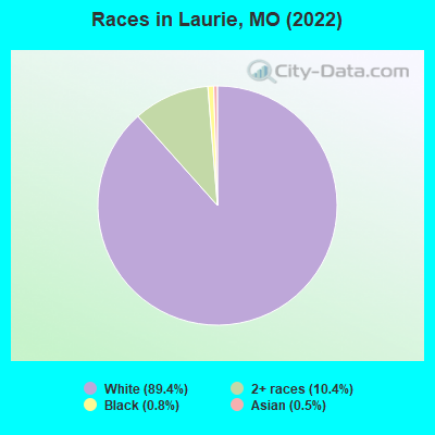
Races in Laurie detailed stats: ancestries, foreign born residents, place of birth
According to our research of Missouri and other state lists, there was 1 registered sex offender living in Laurie, Missouri as of April 19, 2024.
The ratio of all residents to sex offenders in Laurie is 989 to 1.
The ratio of registered sex offenders to all residents in this city is much lower than the state average.
Type |
2009 |
2010 |
2011 |
2012 |
2013 |
2014 |
2015 |
2016 |
2017 |
2018 |
2019 |
2020 |
2021 |
2022 |
|---|---|---|---|---|---|---|---|---|---|---|---|---|---|---|
| Murders (per 100,000) | 0 (0.0) | 0 (0.0) | 0 (0.0) | 0 (0.0) | 0 (0.0) | 0 (0.0) | 0 (0.0) | 0 (0.0) | 0 (0.0) | 0 (0.0) | 0 (0.0) | 0 (0.0) | 0 (0.0) | 0 (0.0) |
| Rapes (per 100,000) | 0 (0.0) | 0 (0.0) | 1 (105.5) | 0 (0.0) | 0 (0.0) | 0 (0.0) | 0 (0.0) | 0 (0.0) | 0 (0.0) | 0 (0.0) | 0 (0.0) | 1 (103.2) | 0 (0.0) | 2 (194.7) |
| Robberies (per 100,000) | 0 (0.0) | 0 (0.0) | 1 (105.5) | 0 (0.0) | 0 (0.0) | 0 (0.0) | 0 (0.0) | 0 (0.0) | 0 (0.0) | 0 (0.0) | 0 (0.0) | 0 (0.0) | 0 (0.0) | 0 (0.0) |
| Assaults (per 100,000) | 2 (270.3) | 2 (211.6) | 2 (211.0) | 3 (318.1) | 6 (652.2) | 7 (751.9) | 3 (322.9) | 3 (322.9) | 2 (214.6) | 0 (0.0) | 4 (422.4) | 3 (309.6) | 4 (406.9) | 1 (97.4) |
| Burglaries (per 100,000) | 8 (1,081) | 10 (1,058) | 6 (632.9) | 9 (954.4) | 6 (652.2) | 14 (1,504) | 5 (538.2) | 2 (215.3) | 15 (1,609) | 5 (534.8) | 5 (528.0) | 2 (206.4) | 1 (101.7) | 2 (194.7) |
| Thefts (per 100,000) | 49 (6,622) | 34 (3,598) | 31 (3,270) | 17 (1,803) | 20 (2,174) | 28 (3,008) | 20 (2,153) | 17 (1,830) | 22 (2,361) | 37 (3,957) | 21 (2,218) | 8 (825.6) | 22 (2,238) | 13 (1,266) |
| Auto thefts (per 100,000) | 0 (0.0) | 0 (0.0) | 2 (211.0) | 1 (106.0) | 0 (0.0) | 3 (322.2) | 2 (215.3) | 0 (0.0) | 3 (321.9) | 0 (0.0) | 0 (0.0) | 0 (0.0) | 1 (101.7) | 5 (486.9) |
| Arson (per 100,000) | 0 (0.0) | 0 (0.0) | 0 (0.0) | 0 (0.0) | 0 (0.0) | 0 (0.0) | 0 (0.0) | 0 (0.0) | 0 (0.0) | 0 (0.0) | 0 (0.0) | 0 (0.0) | 0 (0.0) | 0 (0.0) |
| City-Data.com crime index | 394.6 | 260.3 | 350.2 | 211.0 | 263.0 | 401.7 | 205.6 | 152.9 | 275.8 | 195.7 | 210.1 | 192.0 | 186.2 | 278.5 |
The City-Data.com crime index weighs serious crimes and violent crimes more heavily. Higher means more crime, U.S. average is 246.1. It adjusts for the number of visitors and daily workers commuting into cities.
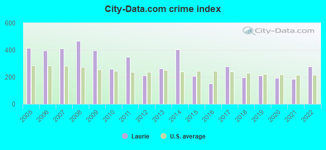
Crime rate in Laurie detailed stats: murders, rapes, robberies, assaults, burglaries, thefts, arson
Full-time law enforcement employees in 2021, including police officers: 5 (5 officers - 5 male; 0 female).
| Officers per 1,000 residents here: | 5.09 |
| Missouri average: | 2.54 |
 Recent articles from our blog. Our writers, many of them Ph.D. graduates or candidates, create easy-to-read articles on a wide variety of topics.

 | Interesting Missouri facts. (1186 replies) |
| Ozark (67 replies) |
| The NFL in St. Louis (28 replies) |
| Wanted: Johnson Countians Willing To Talk About Kansas Now With Me (204 replies) |
| Governor to sigh 'Right to Work' law today! (38 replies) |
| When I was a kid in KC (40 replies) |
Latest news from Laurie, MO collected exclusively by city-data.com from local newspapers, TV, and radio stations
Ancestries: German (28.7%), English (18.3%), American (14.8%), Scotch-Irish (6.0%), Irish (4.7%), Norwegian (2.1%).
Current Local Time: CST time zone
Incorporated in 1966
Elevation: 965 feet
Land area: 5.26 square miles.
Population density: 193 people per square mile (very low).
2 residents are foreign born
| This village: | 0.2% |
| Missouri: | 4.2% |
Median real estate property taxes paid for housing units with mortgages in 2022: $766 (0.5%)
Median real estate property taxes paid for housing units with no mortgage in 2022: $1,322 (0.6%)
Nearest city with pop. 50,000+: Columbia, MO  (58.1 miles , pop. 84,531).
Nearest city with pop. 200,000+: Kansas City, MO (111.1 miles , pop. 441,545).
Nearest city with pop. 1,000,000+: Chicago, IL (370.9 miles , pop. 2,896,016).
Nearest cities:
), Latitude: 38.20 N, Longitude: 92.83 W
Area code commonly used in this area: 573
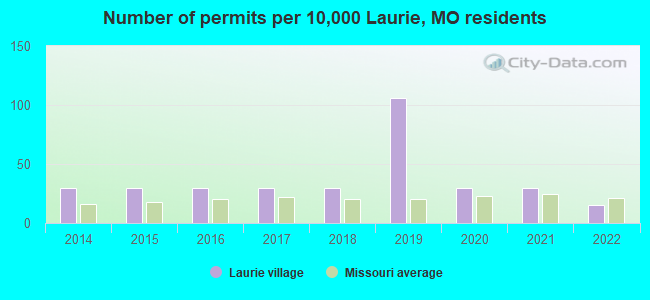
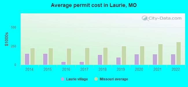
Single-family new house construction building permits:
- 2022: 1 building, cost: $145,000
- 2021: 2 buildings, average cost: $145,000
- 2020: 2 buildings, average cost: $145,000
- 2019: 7 buildings, average cost: $102,100
- 2018: 2 buildings, average cost: $135,000
- 2017: 2 buildings, average cost: $41,000
- 2016: 2 buildings, average cost: $41,000
- 2015: 2 buildings, average cost: $150,000
- 2014: 2 buildings, average cost: $150,000
| Here: | 3.8% |
| Missouri: | 2.8% |
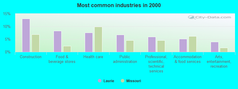
- Construction (13.0%)
- Food & beverage stores (8.3%)
- Health care (7.5%)
- Public administration (6.7%)
- Professional, scientific, technical services (5.9%)
- Accommodation & food services (5.1%)
- Arts, entertainment, recreation (4.0%)
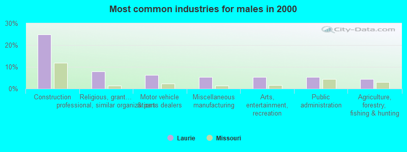
- Construction (24.8%)
- Religious, grantmaking, civic, professional, similar organizations (8.0%)
- Motor vehicle & parts dealers (6.2%)
- Miscellaneous manufacturing (5.3%)
- Arts, entertainment, recreation (5.3%)
- Public administration (5.3%)
- Agriculture, forestry, fishing & hunting (4.4%)
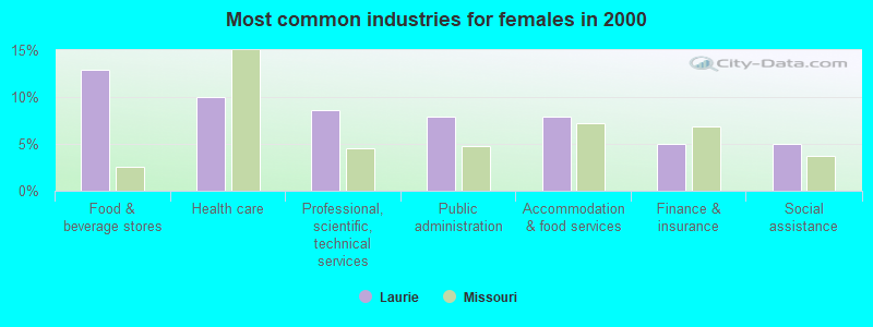
- Food & beverage stores (12.9%)
- Health care (10.0%)
- Professional, scientific, technical services (8.6%)
- Public administration (7.9%)
- Accommodation & food services (7.9%)
- Finance & insurance (5.0%)
- Social assistance (5.0%)
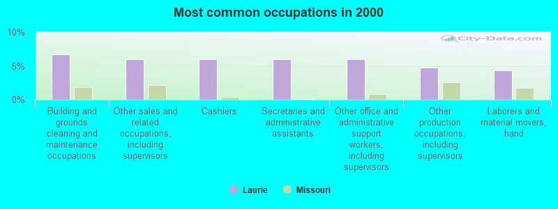
- Building and grounds cleaning and maintenance occupations (6.7%)
- Other sales and related occupations, including supervisors (5.9%)
- Cashiers (5.9%)
- Secretaries and administrative assistants (5.9%)
- Other office and administrative support workers, including supervisors (5.9%)
- Other production occupations, including supervisors (4.7%)
- Laborers and material movers, hand (4.3%)
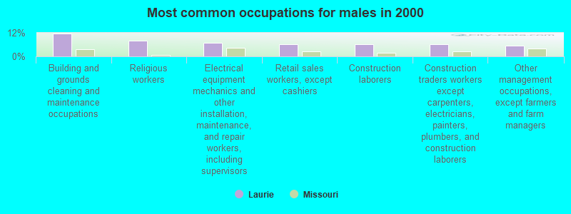
- Building and grounds cleaning and maintenance occupations (11.5%)
- Religious workers (8.0%)
- Electrical equipment mechanics and other installation, maintenance, and repair workers, including supervisors (7.1%)
- Retail sales workers, except cashiers (6.2%)
- Construction laborers (6.2%)
- Construction traders workers except carpenters, electricians, painters, plumbers, and construction laborers (6.2%)
- Other management occupations, except farmers and farm managers (5.3%)
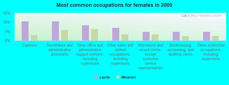
- Cashiers (10.7%)
- Secretaries and administrative assistants (10.7%)
- Other office and administrative support workers, including supervisors (8.6%)
- Other sales and related occupations, including supervisors (7.1%)
- Information and record clerks, except customer service representatives (5.0%)
- Bookkeeping, accounting, and auditing clerks (5.0%)
- Other production occupations, including supervisors (5.0%)
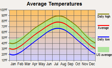
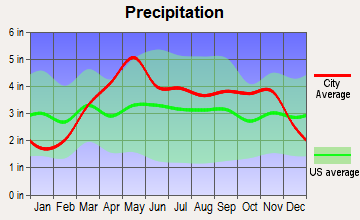
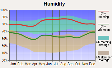
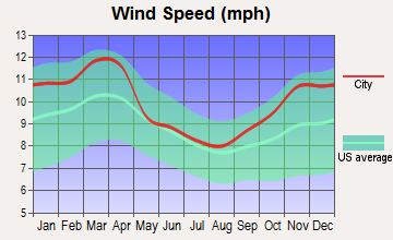
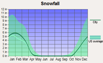
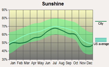
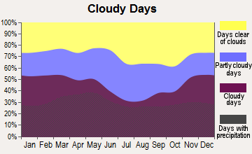
Average climate in Laurie, Missouri
Based on data reported by over 4,000 weather stations
Tornado activity:
Laurie-area historical tornado activity is slightly below Missouri state average. It is 26% greater than the overall U.S. average.
On 5/4/2003, a category F3 (max. wind speeds 158-206 mph) tornado 20.9 miles away from the Laurie village center killed 4 people and injured 27 people and caused $5 million in damages.
On 4/19/1973, a category F4 (max. wind speeds 207-260 mph) tornado 44.2 miles away from the village center injured 5 people and caused between $5000 and $50,000 in damages.
Earthquake activity:
Laurie-area historical earthquake activity is significantly above Missouri state average. It is 470% greater than the overall U.S. average.On 9/3/2016 at 12:02:44, a magnitude 5.8 (5.8 MW, Depth: 3.5 mi, Class: Moderate, Intensity: VI - VII) earthquake occurred 256.9 miles away from Laurie center
On 11/6/2011 at 03:53:10, a magnitude 5.7 (5.7 MW, Depth: 3.2 mi) earthquake occurred 285.6 miles away from the city center
On 4/18/2008 at 09:36:59, a magnitude 5.4 (5.1 MB, 4.8 MS, 5.4 MW, 5.2 MW) earthquake occurred 268.7 miles away from Laurie center
On 9/26/1990 at 13:18:51, a magnitude 5.0 (4.7 MB, 4.8 LG, 5.0 LG, Depth: 7.7 mi) earthquake occurred 194.0 miles away from Laurie center
On 5/4/1991 at 01:18:54, a magnitude 5.0 (4.4 MB, 4.6 LG, 5.0 LG, Depth: 3.1 mi) earthquake occurred 200.4 miles away from Laurie center
On 3/25/1976 at 00:41:20, a magnitude 5.0 (4.9 MB, 5.0 LG) earthquake occurred 225.1 miles away from Laurie center
Magnitude types: regional Lg-wave magnitude (LG), body-wave magnitude (MB), surface-wave magnitude (MS), moment magnitude (MW)
Natural disasters:
The number of natural disasters in Morgan County (23) is greater than the US average (15).Major Disasters (Presidential) Declared: 15
Emergencies Declared: 6
Causes of natural disasters: Floods: 14, Storms: 13, Tornadoes: 9, Winter Storms: 5, Winds: 4, Drought: 1, Heavy Rain: 1, Hurricane: 1, Ice Storm: 1, Snowstorm: 1, Other: 1 (Note: some incidents may be assigned to more than one category).

Hospitals and medical centers in Laurie:
Other hospitals and medical centers near Laurie:
- OZARK REHABILITATION AND HEALTH CARE CENTER (Nursing Home, about 10 miles away; OSAGE BEACH, MO)
- OSAGE BEACH REHABILITATION AND HEALTH CARE CENTER (Nursing Home, about 13 miles away; OSAGE BEACH, MO)
- LAKESIDE MEADOWS-A STONEBRIDGE COMMUNITY (Nursing Home, about 14 miles away; OSAGE BEACH, MO)
- GOOD SHEPHERD CARE CENTER (Nursing Home, about 16 miles away; VERSAILLES, MO)
Airports located in Laurie:
- Bar-Vik Airport (MO89) (Runways: 1)
Colleges/universities with over 2000 students nearest to Laurie:
- State Fair Community College (about 42 miles; Sedalia, MO; Full-time enrollment: 3,581)
- Lincoln University (about 44 miles; Jefferson City, MO; FT enrollment: 2,348)
- Southwest Baptist University (about 53 miles; Bolivar, MO; FT enrollment: 2,783)
- University of Missouri-Columbia (about 58 miles; Columbia, MO; FT enrollment: 29,599)
- Columbia College (about 59 miles; Columbia, MO; FT enrollment: 13,975)
- Missouri University of Science and Technology (about 60 miles; Rolla, MO; FT enrollment: 6,486)
- University of Central Missouri (about 63 miles; Warrensburg, MO; FT enrollment: 9,952)
Points of interest:
Notable locations in Laurie: Gravois Fire Protection District G - 7 (A), Gravois Fire Protection District (B). Display/hide their locations on the map
Churches in Laurie include: Saint Patricks Church (A), Shrine of Saint Patrick (B), Ozark Chapel (C). Display/hide their locations on the map
Cemeteries: Buckley Cemetery (1), Garber Memorial Cemetery (2), Saint Patrick Cemetery (3). Display/hide their locations on the map
Drinking water stations with addresses in Laurie and their reported violations in the past:
OSAGE COMMUNITY ELKS LODGE 2705 (Population served: 150, Groundwater):Past health violations:MICKEYLAND RESORT (Population served: 50, Groundwater):Past monitoring violations:
- MCL, Monthly (TCR) - In JUN-2014, Contaminant: Coliform. Follow-up actions: St Formal NOV issued (JUN-20-2014), St Public Notif requested (JUN-20-2014)
- MCL, Monthly (TCR) - In OCT-2010, Contaminant: Coliform. Follow-up actions: St Public Notif requested (OCT-27-2010), St Violation/Reminder Notice (OCT-27-2010), St Public Notif received (NOV-03-2010), St Compliance achieved (AUG-12-2011)
- Monitoring, Source Water (GWR) - In OCT-01-2012, Contaminant: E. COLI. Follow-up actions: St Public Notif requested (OCT-19-2012), St Violation/Reminder Notice (OCT-19-2012), St Public Notif received (NOV-13-2012)
- Monitoring, Repeat Major (TCR) - In SEP-2012, Contaminant: Coliform (TCR). Follow-up actions: St Public Notif requested (OCT-19-2012), St Violation/Reminder Notice (OCT-19-2012), St Public Notif received (NOV-13-2012), St Compliance achieved (JAN-22-2014)
- 2 minor monitoring violations
Past health violations:THE LAKE HOUSE INN (Population served: 30, Groundwater):Past monitoring violations:
- MCL, Monthly (TCR) - In JUN-2013, Contaminant: Coliform. Follow-up actions: St Consent Decree/Judgement (APR-17-2013), St Public Notif requested (JUL-09-2013), St Formal NOV issued (JUL-09-2013)
- MCL, Monthly (TCR) - In MAY-2013, Contaminant: Coliform. Follow-up actions: St Consent Decree/Judgement (APR-17-2013), St Public Notif requested (JUN-11-2013), St Formal NOV issued (JUN-11-2013)
- MCL, Monthly (TCR) - In DEC-2012, Contaminant: Coliform. Follow-up actions: St Public Notif requested (DEC-19-2012), St Formal NOV issued (DEC-19-2012), St Consent Decree/Judgement (APR-17-2013)
- MCL, Monthly (TCR) - In JUN-2012, Contaminant: Coliform. Follow-up actions: St Civil Case referred to AG (SEP-24-2010), St Public Notif requested (JUL-06-2012), St Violation/Reminder Notice (JUL-06-2012), St Consent Decree/Judgement (APR-17-2013)
- MCL, Monthly (TCR) - In MAR-2012, Contaminant: Coliform. Follow-up actions: St Civil Case referred to AG (SEP-24-2010), St Public Notif requested (APR-06-2012), St Violation/Reminder Notice (APR-06-2012), St Consent Decree/Judgement (APR-17-2013)
- MCL, Monthly (TCR) - In AUG-2011, Contaminant: Coliform. Follow-up actions: St Civil Case referred to AG (SEP-24-2010), St Public Notif requested (AUG-15-2011), St Violation/Reminder Notice (AUG-15-2011), St Consent Decree/Judgement (APR-17-2013)
- 6 other older health violations
- Monitoring, Source Water (GWR) - In JAN-01-2013, Contaminant: E. COLI. Follow-up actions: St Public Notif requested (FEB-01-2013), St Violation/Reminder Notice (FEB-01-2013), St Consent Decree/Judgement (APR-17-2013)
- Failure To Address Deficiency - In SEP-09-2012, Contaminant: GROUNDWATER RULE. Follow-up actions: St Consent Decree/Judgement (APR-17-2013), St Public Notif requested (JUN-07-2013), St Formal NOV issued (JUN-07-2013)
- Monitoring, Source Water (GWR) - In JUL-01-2012, Contaminant: E. COLI. Follow-up actions: St Public Notif requested (JUL-18-2012), St Violation/Reminder Notice (JUL-18-2012), St Consent Decree/Judgement (APR-17-2013)
- Monitoring, Source Water (GWR) - In JUN-01-2012, Contaminant: E. COLI. Follow-up actions: St Civil Case referred to AG (SEP-24-2010), St Public Notif requested (JUN-21-2012), St Violation/Reminder Notice (JUN-21-2012), St Consent Decree/Judgement (APR-17-2013)
- Monitoring, Repeat Major (TCR) - In MAY-2012, Contaminant: Coliform (TCR). Follow-up actions: St Civil Case referred to AG (SEP-24-2010), St Public Notif requested (JUN-21-2012), St Violation/Reminder Notice (JUN-21-2012), St Consent Decree/Judgement (APR-17-2013)
- 4 routine major monitoring violations
- 7 minor monitoring violations
- 2 regular monitoring violations
- 2 other older monitoring violations
Past health violations:VINNYS CAFE AND LOUNGE (Population served: 25, Groundwater):
- MCL, Monthly (TCR) - In OCT-2005, Contaminant: Coliform. Follow-up actions: St Violation/Reminder Notice (NOV-07-2005), St Public Notif requested (NOV-07-2005), St Public Notif received (NOV-21-2005), St Compliance achieved (JAN-22-2014)
- MCL, Monthly (TCR) - In SEP-2005, Contaminant: Coliform. Follow-up actions: St Violation/Reminder Notice (OCT-21-2005), St Public Notif requested (OCT-21-2005), St Public Notif received (NOV-28-2005), St Compliance achieved (JAN-22-2014)
Past health violations:Past monitoring violations:
- MCL, Monthly (TCR) - In JUL-2010, Contaminant: Coliform. Follow-up actions: St Public Notif requested (JUL-30-2010), St Violation/Reminder Notice (JUL-30-2010), St BCA signed (SEP-16-2010), St Compliance achieved (2 times from DEC-31-2010 to OCT-05-2011)
- MCL, Monthly (TCR) - In JUN-2010, Contaminant: Coliform. Follow-up actions: St Public Notif requested (JUN-25-2010), St Violation/Reminder Notice (JUN-25-2010), St BCA signed (SEP-16-2010), St Compliance achieved (2 times from DEC-31-2010 to OCT-05-2011)
- MCL, Monthly (TCR) - In NOV-2009, Contaminant: Coliform. Follow-up actions: St Public Notif requested (DEC-03-2009), St Violation/Reminder Notice (DEC-03-2009), St BCA signed (SEP-16-2010), St Compliance achieved (2 times from SEP-30-2010 to OCT-05-2011)
- MCL, Monthly (TCR) - In SEP-2009, Contaminant: Coliform. Follow-up actions: St Public Notif requested (SEP-29-2009), St Formal NOV issued (SEP-29-2009), St Violation/Reminder Notice (OCT-01-2009), St Public Notif requested (OCT-01-2009), St BCA signed (SEP-16-2010), St Compliance achieved (2 times from SEP-30-2010 to OCT-05-2011)
- MCL, Acute (TCR) - In SEP-2009, Contaminant: Coliform. Follow-up actions: St Public Notif issued (SEP-29-2009), St Public Notif requested (SEP-29-2009), St Formal NOV issued (SEP-29-2009), St Boil Water Order (SEP-29-2009), St Formal NOV issued (OCT-01-2009), St Public Notif requested (OCT-01-2009), St Other (OCT-02-2009), St BCA signed (SEP-16-2010), St Compliance achieved (2 times from SEP-30-2010 to OCT-05-2011)
- MCL, Monthly (TCR) - In AUG-2009, Contaminant: Coliform. Follow-up actions: St Formal NOV issued (AUG-24-2009), St Public Notif requested (AUG-28-2009), St Violation/Reminder Notice (AUG-28-2009), St Public Notif requested (AUG-28-2009), St Violation/Reminder Notice (AUG-28-2009), St BCA signed (SEP-16-2010), St Compliance achieved (2 times from SEP-30-2010 to OCT-05-2011)
- 3 other older health violations
- Monitoring, Source Water (GWR) - In JUL-01-2010, Contaminant: E. COLI. Follow-up actions: St Public Notif requested (AUG-30-2010), St Violation/Reminder Notice (AUG-30-2010), St BCA signed (SEP-16-2010), St Compliance achieved (2 times from SEP-16-2011 to OCT-05-2011)
- Monitoring, Repeat Major (TCR) - In SEP-2008, Contaminant: Coliform (TCR). Follow-up actions: St Violation/Reminder Notice (OCT-31-2008), St Public Notif requested (OCT-31-2008), St Compliance achieved (SEP-30-2010)
- 2 routine major monitoring violations
- 2 minor monitoring violations
| This village: | 1.9 people |
| Missouri: | 2.5 people |
| This village: | 52.7% |
| Whole state: | 65.3% |
| This village: | 6.3% |
| Whole state: | 6.7% |
Likely homosexual households (counted as self-reported same-sex unmarried-partner households)
- Lesbian couples: 0.2% of all households
- Gay men: 0.0% of all households
89 people in nursing homes in 2000
Banks with branches in Laurie (2011 data):
- The Bank of Versailles: Laurie Banking Facility at Highway 5 And Route O, branch established on 1977/03/29. Info updated 2006/11/03: Bank assets: $265.0 mil, Deposits: $239.1 mil, headquarters in Versailles, MO, negative income in the last year, Mortgage Lending Specialization, 4 total offices, Holding Company: Bov Holding Company
- Central Bank of Lake of the Ozarks: Laurie Branch at 101 Dogwood Lane, branch established on 1997/12/29. Info updated 2011/04/06: Bank assets: $502.1 mil, Deposits: $445.3 mil, headquarters in Osage Beach, MO, positive income, Commercial Lending Specialization, 9 total offices, Holding Company: Central Bancompany
- U.S. Bank National Association: Laurie Branch at 409 North Main Street, branch established on 1984/04/17. Info updated 2012/01/30: Bank assets: $330,470.8 mil, Deposits: $236,091.5 mil, headquarters in Cincinnati, OH, positive income, 3121 total offices, Holding Company: U.S. Bancorp
- Concordia Bank of Concordia, Missouri: Laurie Branch at 504 North Main Street, branch established on 2001/03/12. Info updated 2010/08/12: Bank assets: $56.6 mil, Deposits: $49.0 mil, headquarters in Concordia, MO, positive income, Commercial Lending Specialization, 4 total offices, Holding Company: Concordia Banc-Management, Inc.
For population 15 years and over in Laurie:
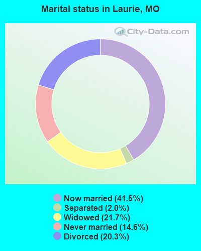
- Never married: 14.6%
- Now married: 41.5%
- Separated: 2.0%
- Widowed: 21.7%
- Divorced: 20.3%
For population 25 years and over in Laurie:
- High school or higher: 93.6%
- Bachelor's degree or higher: 9.6%
- Graduate or professional degree: 4.8%
- Unemployed: 1.2%
- Mean travel time to work (commute): 17.1 minutes
| Here: | 8.5 |
| Missouri average: | 11.1 |
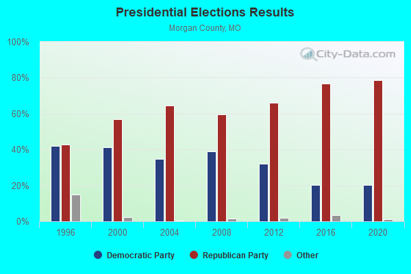
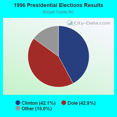
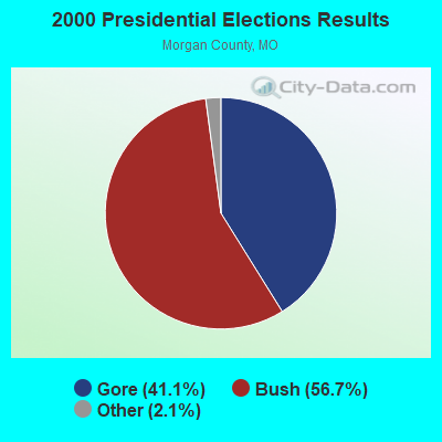
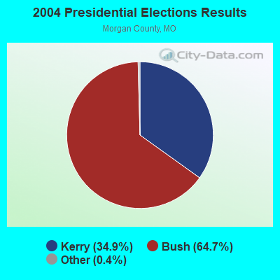
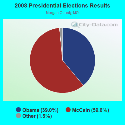
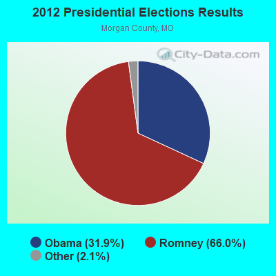
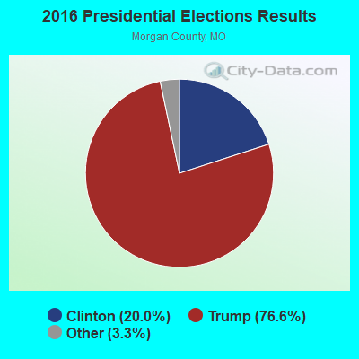
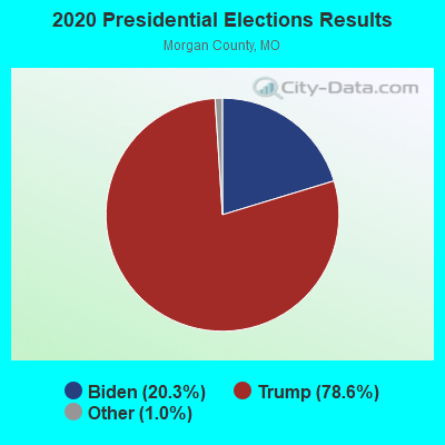
Graphs represent county-level data. Detailed 2008 Election Results
Religion statistics for Laurie, MO (based on Morgan County data)
| Religion | Adherents | Congregations |
|---|---|---|
| Evangelical Protestant | 5,887 | 35 |
| Mainline Protestant | 2,117 | 14 |
| Catholic | 1,278 | 2 |
| Other | 1 | 1 |
| None | 11,282 | - |
Food Environment Statistics:
| This county: | 4.33 / 10,000 pop. |
| Missouri: | 1.88 / 10,000 pop. |
| This county: | 7.69 / 10,000 pop. |
| State: | 4.34 / 10,000 pop. |
| Here: | 12.02 / 10,000 pop. |
| Missouri: | 7.37 / 10,000 pop. |
| Morgan County: | 9.5% |
| Missouri: | 8.8% |
| Morgan County: | 27.6% |
| State: | 29.6% |
| Morgan County: | 14.3% |
| State: | 13.5% |
Health and Nutrition:
| Laurie: | 44.3% |
| Missouri: | 50.9% |
| This city: | 46.7% |
| Missouri: | 48.6% |
| This city: | 29.1 |
| Missouri: | 28.7 |
| Here: | 27.6% |
| State: | 20.6% |
| This city: | 12.9% |
| Missouri: | 10.1% |
| Laurie: | 6.1 |
| Missouri: | 6.8 |
| Laurie: | 36.8% |
| State: | 34.3% |
| This city: | 57.0% |
| Missouri: | 57.5% |
| Laurie: | 80.1% |
| State: | 79.3% |
More about Health and Nutrition of Laurie, MO Residents
| Local government employment and payroll (March 2022) | |||||
| Function | Full-time employees | Monthly full-time payroll | Average yearly full-time wage | Part-time employees | Monthly part-time payroll |
|---|---|---|---|---|---|
| Police Protection - Officers | 7 | $22,466 | $38,513 | 0 | $0 |
| Parks and Recreation | 2 | $4,725 | $28,350 | 0 | $0 |
| Other Government Administration | 1 | $4,699 | $56,388 | 0 | $0 |
| Streets and Highways | 1 | $2,440 | $29,280 | 0 | $0 |
| Water Supply | 1 | $3,419 | $41,028 | 1 | $1,351 |
| Sewerage | 1 | $3,131 | $37,572 | 2 | $2,378 |
| Totals for Government | 13 | $40,880 | $37,735 | 3 | $3,729 |
Laurie government finances - Expenditure in 2017 (per resident):
- Construction - Regular Highways: $25,000 ($24.63)
- Current Operations - Police Protection: $195,000 ($192.12)
Sewerage: $61,000 ($60.10)
Water Utilities: $61,000 ($60.10)
Central Staff Services: $58,000 ($57.14)
General Public Buildings: $56,000 ($55.17)
Parks and Recreation: $39,000 ($38.42)
Regular Highways: $38,000 ($37.44)
Judicial and Legal Services: $18,000 ($17.73)
Financial Administration: $15,000 ($14.78)
- Total Salaries and Wages: $396,000 ($390.15)
- Water Utilities - Interest on Debt: $99,000 ($97.54)
Laurie government finances - Revenue in 2017 (per resident):
- Charges - Sewerage: $232,000 ($228.57)
- Miscellaneous - Fines and Forfeits: $29,000 ($28.57)
- Revenue - Water Utilities: $247,000 ($243.35)
- State Intergovernmental - Highways: $93,000 ($91.63)
- Tax - General Sales and Gross Receipts: $808,000 ($796.06)
Motor Vehicle License: $4,000 ($3.94)
Occupation and Business License - Other: $4,000 ($3.94)
Alcoholic Beverage License: $3,000 ($2.96)
Laurie government finances - Debt in 2017 (per resident):
- Long Term Debt - Beginning Outstanding - Unspecified Public Purpose: $2,467,000 ($2430.54)
Outstanding Unspecified Public Purpose: $2,297,000 ($2263.05)
Retired Unspecified Public Purpose: $170,000 ($167.49)
- Short Term Debt Outstanding - Beginning: $170,000 ($167.49)
Laurie government finances - Cash and Securities in 2017 (per resident):
- Other Funds - Cash and Securities: $1,169,000 ($1151.72)
- Sinking Funds - Cash and Securities: $539,000 ($531.03)
| Businesses in Laurie, MO | ||||
| Name | Count | Name | Count | |
|---|---|---|---|---|
| AT&T | 1 | SONIC Drive-In | 1 | |
| FedEx | 1 | Subway | 1 | |
| Pizza Hut | 1 | U-Haul | 1 | |
| RadioShack | 1 | UPS | 1 | |
Strongest AM radio stations in Laurie:
- KRMS (1150 AM; 10 kW; OSAGE BEACH, MO; Owner: VIPER COMMUNICATIONS, INC)
- KBNN (750 AM; daytime; 5 kW; LEBANON, MO; Owner: OZARK BROADCASTING, INC.)
- WHB (810 AM; 50 kW; KANSAS CITY, MO; Owner: UNION BROADCASTING, INC.)
- KWOS (950 AM; 5 kW; JEFFERSON CITY, MO; Owner: ZIMMER RADIO OF MID-MISSOURI, INC.)
- KLIK (1240 AM; 5 kW; JEFFERSON CITY, MO; Owner: PREMIER RADIO GROUP)
- KXEN (1010 AM; 50 kW; FESTUS-ST. LOUIS, MO; Owner: BDJ RADIO ENTERPRISES, LLC)
- KMOX (1120 AM; 50 kW; ST. LOUIS, MO; Owner: INFINITY BROADCASTING OPERATIONS, INC.)
- KJPW (1390 AM; 5 kW; WAYNESVILLE, MO; Owner: PULASKI COUNTY BROADCASTERS, INC.)
- KKHK (1250 AM; 25 kW; KANSAS CITY, KS)
- KRMG (740 AM; 50 kW; TULSA, OK; Owner: CXR HOLDINGS, INC.)
- KWTO (560 AM; 5 kW; SPRINGFIELD, MO; Owner: KWTO, INC.)
- WCRV (640 AM; 50 kW; COLLIERVILLE, TN; Owner: BOTT BROADCASTING COMPANY/TENNESSEE)
- KCMO (710 AM; 10 kW; KANSAS CITY, MO; Owner: SUSQUEHANNA KANSAS CITY PARTNERSHIP)
Strongest FM radio stations in Laurie:
- KCRL (90.3 FM; SUNRISE BEACH, MO; Owner: COMMUNITY BROADCASTING INC)
- KRMS-FM (93.5 FM; OSAGE BEACH, MO; Owner: VIPER COMMUNICATIONS, INC.)
- K285ER (104.9 FM; OSAGE BEACH, MO; Owner: BD OF GOVERNORS, CENTRAL MO ST. U.)
- KLOZ (92.7 FM; ELDON, MO; Owner: BENNE BROADCASTING COMPANY, LLC)
- KCVO-FM (91.7 FM; CAMDENTON, MO; Owner: LAKE AREA EDUCATIONAL BROADCASTING FOUNDATION)
- KTKS (95.1 FM; VERSAILLES, MO; Owner: TWIN LAKES COMMUNICATIONS, INC.)
- KJEL (103.7 FM; LEBANON, MO; Owner: OZARK BROADCASTING, INC.)
- KTXY (106.9 FM; JEFFERSON CITY, MO; Owner: ZIMMER RADIO OF MID-MISSOURI, INC.)
- KLRQ (96.1 FM; CLINTON, MO; Owner: B & F BROADCASTING, INC.)
- KQUL (102.7 FM; LAKE OZARK, MO; Owner: BENNE B/CO CO. OF LAKE OZARK,INC)
- KOQL (106.1 FM; ASHLAND, MO; Owner: MID-MISSOURI BROADCASTING, INC.)
- KWKJ (98.5 FM; WINDSOR, MO; Owner: D & H MEDIA, LLC)
- KCLQ (107.9 FM; LEBANON, MO; Owner: PEARSON BROADCASTING OF LEBANON, INC.)
- KBBM (100.1 FM; JEFFERSON CITY, MO; Owner: PREMIER RADIO GROUP)
- KFBD-FM (97.9 FM; WAYNESVILLE, MO; Owner: FIDELITY BROADCASTING, INC.)
- KCVK (107.7 FM; OTTERVILLE, MO; Owner: LAKE AREA EDUCATIONAL BROADCASTING FOUNDATION)
TV broadcast stations around Laurie:
- KMOS-TV (Channel 6; SEDALIA, MO; Owner: BOARD OF GOVERNORS OF CENTRAL MISSOURI STATE UNIVERSITY)
- KMIZ (Channel 17; COLUMBIA, MO; Owner: CHELSEY BROADCASTING COMPANY OF COLUMBIA, LLC)
- K32FH (Channel 32; WARRENSBURG, MO; Owner: ROGER E. HARDERS)
- K64FQ (Channel 64; LEBANON, MO; Owner: NEW LIFE EVANGELISTIC CENTER, INC.)
- Laurie, Missouri
- Fatal accident count10
- Vehicles involved in fatal accidents13
- Fatal accidents involving drunk persons:7
- Fatalities10
- Persons involved in fatal accidents18
- Pedestrians involved in fatal accidents0
- Missouri average
- Fatal accident count8208
- Vehicles involved in fatal accidents12510
- Fatal accidents involving drunk persons2802
- Fatalities9223
- Persons involved in fatal accidents20529
- Pedestrians involved in fatal accidents820
- National Bridge Inventory (NBI) Statistics
- 2Number of bridges
- 7ft / 2.4mTotal length
- $140,000Total costs
- 4,597Total average daily traffic
- 916Total average daily truck traffic
- 8,046Total future (year 2041) average daily traffic
FCC Registered Cell Phone Towers:
1 (See the full list of FCC Registered Cell Phone Towers in Laurie)FCC Registered Antenna Towers:
21 (See the full list of FCC Registered Antenna Towers)FCC Registered Broadcast Land Mobile Towers:
5- 0.03 Mi West Of State Highway 5 (Lat: 38.242611 Lon: -92.843806), Type: Ltower, Structure height: 76.2 m, Overall height: 79.2 m, Call Sign: WQF609,
Assigned Frequencies: 154.385 MHz, Grant Date: 08/28/2015, Expiration Date: 10/03/2025, Certifier: Ed Hancock, Registrant: Command 1, LLC, Centertown, MO 65023, Phone: (573) 353-8041, Fax: (573) 550-1364, Email:
- Hwy 5 (Lat: 38.202528 Lon: -92.832139), Call Sign: KNFU436, Licensee ID: L00073213,
Assigned Frequencies: 152.870 MHz, Grant Date: 05/17/2002, Expiration Date: 06/23/2012, Cancellation Date: 08/25/2012, Registrant: James Clary, Sunrise Beach, MO 65079, Phone: (314) 374-5100
- Hwy 5 Jct Hwy 5 & 0 (Lat: 38.208361 Lon: -92.833528), Call Sign: KNCW978,
Assigned Frequencies: 150.845 MHz, Grant Date: 02/27/2002, Expiration Date: 02/27/2012, Cancellation Date: 04/28/2012, Registrant: Kens Dx Service, Rt.1 Box 227-B2, Sunrise Beach, MO 65079, Phone: (573) 374-2758, Email:
- Rt Ra Well 1/2 M S Of Laurie On Hwy 5 (Lat: 38.200167 Lon: -92.825278), Type: Pole, Structure height: 6.1 m, Call Sign: WPTG737,
Assigned Frequencies: 173.362 MHz, Grant Date: 07/20/2011, Expiration Date: 09/28/2021, Cancellation Date: 12/04/2021, Certifier: Ed Young, Registrant: Micro-Comm, Inc., 15895 South Pflumm Road, Olathe, KS 66062, Phone: (913) 390-4500, Fax: (913) 390-4550, Email:
- ROUTE O MM, Route O Master Meter 1398 Highway O (Lat: 38.219667 Lon: -92.806222), Type: Upole, Structure height: 6.1 m, Call Sign: WQGQ325,
Assigned Frequencies: 173.362 MHz, Grant Date: 01/10/2017, Expiration Date: 03/21/2027, Certifier: Ed Young, Registrant: Micro-Comm, Inc, 15895 S Pflumm, Williamsport, KS 66062, Phone: (913) 390-4500, Fax: (570) 323-4002, Email:
FCC Registered Microwave Towers:
5- Laurie W1, Lat: 38.206361 Lon: -92.842667, Type: Tank, Structure height: 37 m, Call Sign: WQMM518,
Assigned Frequencies: 3650.00 MHz, Grant Date: 09/23/2010, Expiration Date: 10/17/2020, Cancellation Date: 12/19/2020, Certifier: James W Petropoulos, Registrant: Lexsar Solutions, Inc., 16533 N State Highway 5 Suite 102, Sunrise Beach, MO 65079, Phone: (573) 374-2288, Email:
- Laurie W2, Lat: 38.206361 Lon: -92.842667, Type: Tank, Structure height: 37 m, Call Sign: WQMM518,
Assigned Frequencies: 3650.00 MHz, Grant Date: 09/23/2010, Expiration Date: 10/17/2020, Cancellation Date: 12/19/2020, Certifier: James W Petropoulos, Registrant: Lexsar Solutions, Inc., 16533 N State Highway 5 Suite 102, Sunrise Beach, MO 65079, Phone: (573) 374-2288, Email:
- Laurie W3, Lat: 38.206361 Lon: -92.842667, Type: Tank, Structure height: 37 m, Call Sign: WQMM518,
Assigned Frequencies: 3650.00 MHz, Grant Date: 09/23/2010, Expiration Date: 10/17/2020, Cancellation Date: 12/19/2020, Certifier: James W Petropoulos, Registrant: Lexsar Solutions, Inc., 16533 N State Highway 5 Suite 102, Sunrise Beach, MO 65079, Phone: (573) 374-2288, Email:
- PURVIS, 582 Hwy Ra (Lat: 38.199222 Lon: -92.852444), Type: Ltower, Structure height: 79.2 m, Call Sign: WRJN503,
Assigned Frequencies: 10815.0 MHz, 10895.0 MHz, Grant Date: 09/29/2020, Expiration Date: 09/29/2030, Certifier: Kevin Hetrick, Registrant: At&t Services, Inc., 208 S Akard St, 20f, Dallas, TX 75202, Phone: (855) 699-7073, Email:
- MO10406A, 32172 Highway 135 (Mo-10-406a) (Lat: 38.217917 Lon: -92.850694), Type: Ltower, Structure height: 60.7 m, Call Sign: WRVF777,
Assigned Frequencies: 10995.0 MHz, 10995.0 MHz, 10995.0 MHz, 10995.0 MHz, 10995.0 MHz, 10995.0 MHz, 10995.0 MHz, 10995.0 MHz, 10995.0 MHz, 10995.0 MHz, 10995.0 MHz, Grant Date: 11/15/2022, Expiration Date: 11/15/2032, Certifier: Jenny Knopf, Registrant: T-Mobile Usa, Inc., 12920 Se 38th Street, Bellevue, WA 98006, Phone: (425) 383-8401, Fax: (425) 383-4040, Email:
FCC Registered Paging Towers:
1- Hwy 5 South (Lat: 38.188639 Lon: -92.810167), Overall height: 60.4 m, Call Sign: KNKP766,
Assigned Frequencies: 152.780 MHz, Grant Date: 04/02/2019, Expiration Date: 04/01/2029, Registrant: Blooston, Mordkofsky, Dickens, Duffy & Prendergast, LLP, 2120 L Street, Nw, Washington, DC 20037, Phone: (202) 828-5540, Fax: (202) 828-5568
FCC Registered Maritime Coast & Aviation Ground Towers:
1- Blue Anchor Marina State Rd O (Lat: 38.228361 Lon: -92.749083), Type: Building, Overall height: 4 m, Call Sign: KFN301, Licensee ID: L00008881,
Assigned Frequencies: 156.450 MHz, 156.575 MHz, 156.800 MHz, Grant Date: 08/05/1999, Expiration Date: 07/27/2004, Cancellation Date: 09/26/2004, Registrant: Skye Enterprises Inc, State Rd, Laurie, MO 65038
FCC Registered Amateur Radio Licenses:
3- Call Sign: KC0EYM, Grant Date: 02/04/1999, Expiration Date: 02/04/2009, Cancellation Date: 02/05/2011, Registrant: Kelly J Metcalf, Laurie, MO 65038
- Call Sign: KC0FSV, Licensee ID: L00340871, Grant Date: 05/06/1999, Expiration Date: 05/06/2009, Cancellation Date: 04/17/2001, Registrant: Westside Hamsters Amateur Radio Club, Laurie, MO 65038
- Call Sign: N0WH, Previous Call Sign: KC0FSV, Licensee ID: L00340871, Grant Date: 06/04/2011, Expiration Date: 06/04/2021, Cancellation Date: 06/06/2023, Certifier: Gary A Metcalf, Registrant: Westside Hamsters Amateur Radio Club, Laurie, MO 65038
FAA Registered Aircraft:
1- Aircraft: POWERCHUTE PEGASUS (Category: Land, Seats: 2, Weight: Up to 12,499 Pounds), Engine: 2 Cycle
N-Number: 9273X, N9273X, N-9273X, Serial Number: A-155 PEG, Certificate Issue Date: 08/31/2012
Registrant (Individual): Larry R Hendrix, 165 Rockin H Ln, Laurie, MO 65037
- 79.5%Electricity
- 13.8%Utility gas
- 4.9%Bottled, tank, or LP gas
- 1.8%Fuel oil, kerosene, etc.
- 96.1%Electricity
- 3.9%Utility gas
Laurie compared to Missouri state average:
- Median household income below state average.
- Unemployed percentage significantly below state average.
- Black race population percentage significantly below state average.
- Hispanic race population percentage significantly below state average.
- Median age significantly above state average.
- Foreign-born population percentage significantly below state average.
- House age below state average.
- Institutionalized population percentage significantly above state average.
- Number of college students significantly below state average.
- Percentage of population with a bachelor's degree or higher significantly below state average.